
The Tropics - 2026 Hurricane Season
Quiet again in the Atlantic.
At this time, I will be updating the Current Tropical Activity in the morning with the NHC chart. The evening updates will feature any new charts and text updates if needed.
See the Saffir-Simpson Scale for Hurricane Intensity.
Last Update: 7/25 - 3:44 PM


Current Tropical Activity
Focus - Atlantic Ocean
This section will be updated each day, during Hurricane Season,
and more frequently, if there is activity of importance to New England.
Last Update: 7/25 - 3:44 PM - Text/Maps Below
See storm Tracking Below for current active systems
Scroll To Storm Tracking
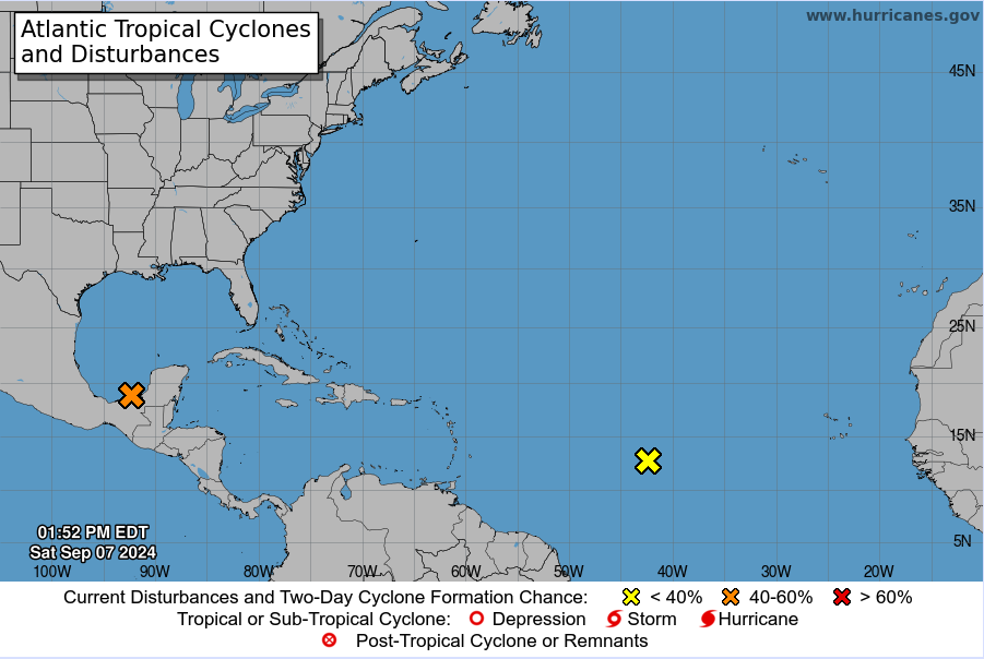
Current activity: Atlantic Ocean
Tropical Weather Outlook
NWS National Hurricane Center Miami FL
200 PM EDT Sat Jul 25 2026
For the North Atlantic...Caribbean Sea and the Gulf of America:
Tropical cyclone formation is not expected during the next 7 days.
Current activity: Eastern Pacific Ocean
Tropical Weather Outlook
NWS National Hurricane Center Miami FL
1100 AM PDT Sat Jul 25 2026
For the eastern and central North Pacific east of 180 longitude:
Active Systems:
The National Hurricane Center is issuing advisories on Hurricane
Fausto, located well east of the Hawaiian Islands, and on Tropical
Storm Genevieve, located well south of the southwestern coast of
Mexico.
1. Well Southwest of Hawaii:
A large area of disorganized showers and thunderstorms located well
southwest of the Hawaiian Islands is associated with a broad area of
low pressure. Environmental conditions appear conducive for gradual
development of this system while it moves generally westward at
about 10 mph toward the International Date Line, and a tropical
depression is likely to form in the western Pacific basin early next
week.
* Formation chance through 48 hours...medium...40 percent.
* Formation chance through 7 days...high...70 percent.


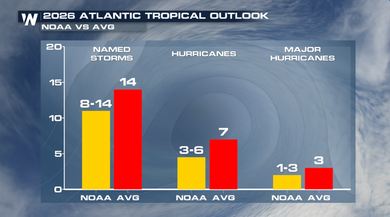
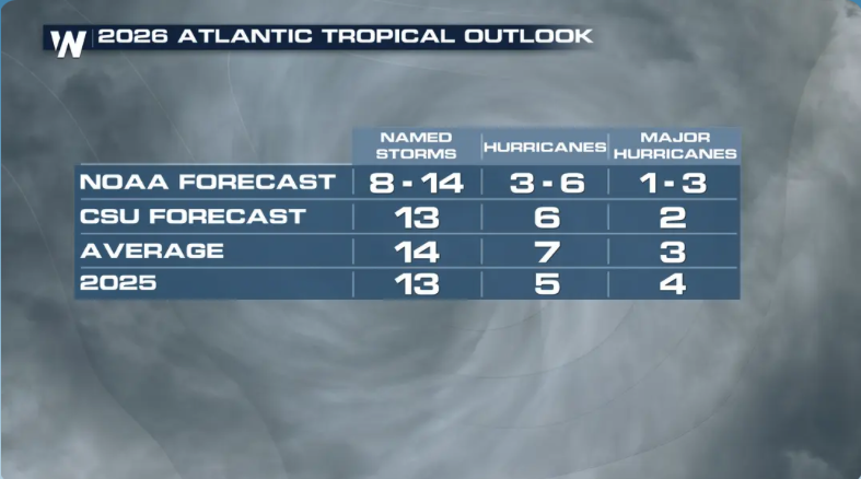
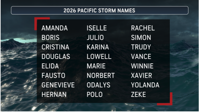
General Information For the 2026 Hurricane Season
If the text below is flashing, scroll down to
the New England Tracking section
Scroll left and right to view the entire table below on mobile devices - Scroll down further to find detailed information on any storms that may affect New England and the northeast. Plan ahead if a storm is headed our way. See the Hurricane Survival Guide
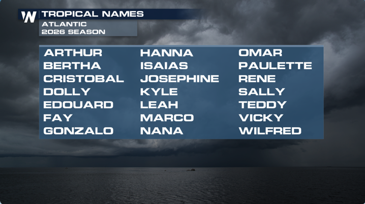
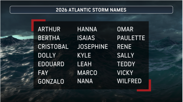
Season 2026 Storm Tracking List
Last Updated: 7/24 - 6:54 AM
(Use the scroll bar at the bottom to scroll right to left on mobile devices)
Current Strength
Last Update
Where is it now?
Highest Wind Speed Recorded
Arthur
Tropical Depression
Final: June 17
35 MPH
...ARTHUR DEGENERATES TO A LOW PRESSURE AREA ALONG THE UPPER
TEXAS COAST...
...LIFE-THREATENING FLOODING EXPECTED TO CONTINUE ACROSS PORTIONS OF THE SOUTHEASTERN UNITED STATES...
This is the last public advisory issued by the National Hurricane
Center on this system.
ABOUT 35 MI...55 KM NNE OF GALVESTON TEXAS
ABOUT 85 MI...135 KM WSW OF LAKE CHARLES LOUISIANA
45 MPH
Bertha
Tropical Storm
Formed 7/20
Final: 7/23
35 MPH
BERTHA HAS DEGENERATED INTO A TROUGH...
...THIS IS THE LAST ADVISORY...
ABOUT 40 MI...65 KM WNW OF HOUSTON TEXAS
60 MPH
Cristobal
Dolly
Edouard
Fay
Gonzalo
Hanna
Isaias
Josephine
Kyle
Leah
Marco
Nana
Omar
Paulette
Rene
Sally
Teddy
Vicky
Wilfred
Just in Case
Just in case
Just in case
Tracking New England Storms
If any Tropical Systems track towards the New England area, you will find detailed maps and storm information below.
Note: Not every tab is populated. Only relevant data is included.
Last update: 5/28 - 9:02 AM
Hurricane Survival Guide
Hurricane "Season" runs from June 1 through November 30.
When a Storm First Threatens:
• Get Ready checklist
• Move quickly without panicking. Start Monitoring the news.
• DON'T be misled by landfall predictions; strong winds could arrive hours before official landfall.
• DON'T heed or spread rumors.
• Review emergency plans with your family. Practice where to go in the house as the hurricane intensifies.
• Get supplies. Follow instructions in this guide for food and water.
• If you plan to leave, start packing.
• Limit traveling to necessary trips.
• Refill any special medications.
• Fill up your car's fuel tank. Make sure you have a spare tire; buy aerosol kits that fix and inflate flats.
• DON'T fill gasoline cans; they are a fire hazard.
• Check battery, water, and oil.
• Check flashlight and radio batteries and have extra on hand.
• Charge rechargeable cellular phones, drills, flashlights, lanterns, batteries.
• Get cash.
• If time allows, get key important documents - passports, wills, contracts, insurance papers, car titles, deeds, leases and tax information - into safe deposit box. If not, put them in a home safe or other safe, dry place
When a Warning is Issued:
• Secure your boat; have aircraft flown out or secured.
• Get shutters, siding or plywood in place on windows. If you haven't sunk sockets, nail wood in with masonry nails.
• DON'T tape windows; tape can create daggers of glass and bake onto panes.
• Move vehicles out of flood-prone areas and into garages if possible. If not, park cars away from trees and close to homes or buildings.
• Move grills, patio furniture and potted plants into house or garage.
• Clear yard of loose objects. If you want to do any last-minute pruning, you must take the clippings inside; trash pickup will have been suspended and you'll be creating a nice pile of missiles.
• Remove swings, and tarps from swing sets. Tie down anything you can't bring in. Check again for loose rain gutters, or moldings.
• Prepare your pool.
• Prepare patio screening. It is built to sustain 75 mph winds but as it fills with wind it can separate from the frame. Officials recommend you remove a 6-foot panel on each side to let wind pass through. Pull out the tubing that holds screening in frame to remove screen.
• Remove roof antenna; unplug antenna wire from set first.
• Remove roof turbines and cap the holes with screw-on turbine caps. Unsecured turbines can fly off and create large hole for rain to pour through.
• Secure anything inside your home that can be thrown around. Tape or tie cabinets. Remove items from counter and table tops. Close closet doors.
• DON'T turn off your natural gas at the main meter. Only emergency or utility people should do that.
When the Storm is Hours Away:
It is now too late to do most of what needs to be done. There is still time to:
• Put on your medic-alert tag.
• Fill your tub and bottles with water.
• Prepare food and water according to rules in the next section.
• Shut your water at the meter to prevent contamination.
• Secure and brace external doors, especially double doors.
• Move as many valuables as possible off the floor to limit flooding damage.
• Move furniture away from windows or cover with plastic.
• Continue to listen to radio and television for instructions.
• Stay off the roads. It's too late to get supplies, and you'll be competing with people trying to flee unsafe homes.
• Stay inside. Conditions will deteriorate rapidly, sometimes hours before landfall and often at night.
Shopping preparations
Water - at least 1 gallon daily per person for 3 to 7 days
Food - at least enough for 3 to 7 days
— non-perishable packaged or canned food / juices
— foods for infants or the elderly
— snack foods
— non-electric can opener
— cooking tools / fuel
— paper plates / plastic utensils
Blankets / Pillows, etc.
Clothing - seasonal / rain gear/ sturdy shoes
First Aid Kit / Medicines / Prescription Drugs
Special Items - for babies and the elderly
Toiletries / Hygiene items / Moisture wipes
Flashlight / Batteries
Radio - Battery operated and NOAA weather radio
Telephones - Fully charged cell phone with extra battery and a traditional (not cordless) telephone set
Cash (with some small bills) and Credit Cards - Banks and ATMs may not be available for extended periods
Keys
Toys, Books and Games
Important documents - in a waterproof container or watertight resealable plastic bag
— insurance, medical records, bank account numbers, Social Security card, etc.
Tools - keep a set with you during the storm
Vehicle fuel tanks filled
Pet care items
— proper identification / immunization records / medications
— ample supply of food and water
— a carrier or cage
— muzzle and leash
During the Storm:
• Stay inside!
• Stay away from windows and doors.
• DON'T use telephone or electrical appliances.
• If storm becomes intense, retreat to designated interior hurricane safe room.
• If you fear your house will come down around you, get into a bathtub and place a mattress over you
Hours after the Storm:
• DON'T leave your home or shelter until emergency officials tell you it's safe. You may only be in the eye, with half the storm - sometimes the stronger half -- still to come.
• If you're not at home, don't return until you get the all-clear. Roads may be blocked by debris. Wait to learn from broadcast reports or shelter officials which roads are passable.
• Driving will be treacherous. Traffic lights will be out and streets filled with debris and downed power lines.
• If your neighborhood floods during the storm, listen to the radio for instructions. Rising water may require you to leave even after the storm has passed.
• Watch and listen for reports of storm-spawned tornadoes.
• DON'T call police, emergency or utility officials unless you have a life-threatening emergency.
• If you must call loved ones to let them know you're all right, be brief to free lines for others.
• DON'T touch power lines. Watch for downed lines. Assume all lines are live unless told otherwise.
• Watch your step. The area will be covered with broken glass and other debris. Parts of your home, your porch, tree limbs and bridges may be weakened and could collapse.
• Watch for insects, snakes and other animals - even alligators - driven out by high water.
• Puddles may conceal dangerous debris or contain sewage or chemicals
The Day After the storm:
• DON'T sight-see. Roads will be clogged.
• You may have to show proof of residency before being allowed back into your neighborhood.
• Use cell phones sparingly; they may be the only working phones, and only a limited number of cells will be operating. Battery use is limited. Also, Many cellular phone towers may be down and cell phones may not work.
The Saffir-Simpson Hurricane Scale
The Saffir-Simpson Hurricane Scale is a 1-5 rating based on the hurricane's present intensity. This is used to give an estimate of the potential property damage and flooding expected along the coast from a hurricane landfall. Wind speed is the determining factor in the scale, as storm surge values are highly dependent on the slope of the continental shelf in the landfall region. Note that all winds are using the U.S. 1-minute average.
Category One Hurricane:
Winds 74-95 mph (64-82 kt or 119-153 km/hr). Storm surge generally 4-5 ft above normal. No real damage to building structures. Damage primarily to unanchored mobile homes, shrubbery, and trees. Some damage to poorly constructed signs. Also, some coastal road flooding and minor pier damage. Hurricanes Allison of 1995 and Danny of 1997 were Category One hurricanes at peak intensity.
Category Two Hurricane:
Winds 96-110 mph (83-95 kt or 154-177 km/hr). Storm surge generally 6-8 feet above normal. Some roofing material, door, and window damage of buildings. Considerable damage to shrubbery and trees with some trees blown down. Considerable damage to mobile homes, poorly constructed signs, and piers. Coastal and low-lying escape routes flood 2-4 hours before arrival of the hurricane center. Small craft in unprotected anchorages break moorings. Hurricane Bonnie of 1998 was a Category Two hurricane when it hit the North Carolina coast, while Hurricane Georges of 1998 was a Category Two Hurricane when it hit the Florida Keys and the Mississippi Gulf Coast.
Category Three Hurricane:
Winds 111-130 mph (96-113 kt or 178-209 km/hr). Storm surge generally 9-12 ft above normal. Some structural damage to small residences and utility buildings with a minor amount of curtain wall failures. Damage to shrubbery and trees with foliage blown off trees and large trees blown down. Mobile homes and poorly constructed signs are destroyed. Low-lying escape routes are cut by rising water 3-5 hours before arrival of the center of the hurricane. Flooding near the coast destroys smaller structures with larger structures damaged by battering from floating debris. Terrain continuously lower than 5 ft above mean sea level may be flooded inland 8 miles (13 km) or more. Evacuation of low-lying residences with several blocks of the shoreline may be required. Hurricanes Roxanne of 1995 and Fran of 1996 were Category Three hurricanes at landfall on the Yucatan Peninsula of Mexico and in North Carolina, respectively.
Category Four Hurricane:
Winds 131-155 mph (114-135 kt or 210-249 km/hr). Storm surge generally 13-18 ft above normal. More extensive curtain wall failures with some complete roof structure failures on small residences. Shrubs, trees, and all signs are blown down. Complete destruction of mobile homes. Extensive damage to doors and windows. Low-lying escape routes may be cut by rising water 3-5 hours before arrival of the center of the hurricane. Major damage to lower floors of structures near the shore. Terrain lower than 10 ft above sea level may be flooded requiring massive evacuation of residential areas as far inland as 6 miles (10 km). Hurricane Luis of 1995 was a Category Four hurricane while moving over the Leeward Islands. Hurricanes Felix and Opal of 1995 also reached Category Four status at peak intensity.
Category Five Hurricane:
Winds greater than 155 mph (135 kt or 249 km/hr). Storm surge generally greater than 18 ft above normal. Complete roof failure on many residences and industrial buildings. Some complete building failures with small utility buildings blown over or away. All shrubs, trees, and signs blown down. Complete destruction of mobile homes. Severe and extensive window and door damage. Low-lying escape routes are cut by rising water 3-5 hours before arrival of the center of the hurricane. Major damage to lower floors of all structures located less than 15 ft above sea level and within 500 yards of the shoreline. Massive evacuation of residential areas on low ground within 5-10 miles (8-16 km) of the shoreline may be required. Hurricane Mitch of 1998 was a Category Five hurricane at peak intensity over the western Caribbean. Hurricane Gilbert of 1988 was a Category Five hurricane at peak intensity and is one of the strongest Atlantic tropical cyclones of record.
Subscribe to my Alerts
Subscribe to my Weather Alerts and get the Every Thursday Evening 'Weeked Outlook'
E-mail.
You manage your subscription.
Cancel whenever you want.
BTW, we do not sell, trade, give away, post, whisper, dream about, tattoo, print or share your e-mail addresses with anyone...EVER!
When you subscribe, your address goes directly to me, not some online service.
Subscribe once and get all e-mails and warnings!
Yes, you can subscribe to multiple addresses, home, office etc.
Zero cost - No ads-No tracking
Just the Weather - No Hype
Add a Richlefko.com app icon to iphone/ipad
Add a RichLefko.com icon to your iPhone or iPad. It is easy. If you find yourself frequently visiting a website or using a web app on your iPhone or iPad, it is very easy to add a shortcut icon directly on your Home screen using Safari that you can quickly tap to launch the site. This is how: How to add a website tile to your iphone or iPad home screen
Proud member of the National Weather Service Skywarn Program