My 24th Year Delivering Weather to New Englanders

Weather for New England and the World
Breaking Weather Headlines
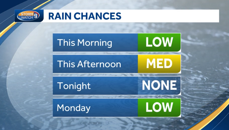
Chance of showers today - Milder
Chance of showers tonight - Mostly cloudy Friday
Next site update willl be Friday night or Saturday morning
See the Weather Discussion below for details

Scroll down for your three day forecast
If the advisory logo above is flashing, there are advisories you should be aware of.
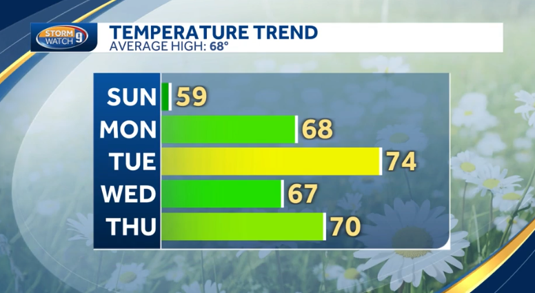
Find the Daily Temperature trend graph here. Scroll to the bottom right.
Your Daily Forecast
Three Days at a time
Updates twice per day, weekdays, by 7:30AM and again by 7:30PM.
9AM and 7PM on Weekends.
Forecasts are for Southern NH (Nashua) to Keene NH with other locations noted.
(PB = Peterborough, NH) - (KE = Keene, NH)
The Weekend Outlooks are added every Thursday morning. (Forecasts through Sunday)
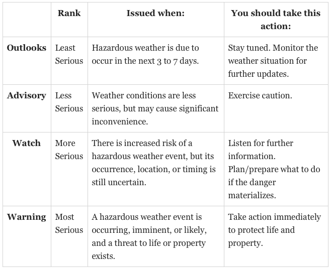
Warnings and/or Advisories
If this is flashing, there are warnings or advisories active
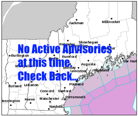
Hazardous Weather Outlook: None
None
Direct Advisory Links:
None
The button below will be wobbling if there is a single advisory type. Click on the button to go to that advisory. If there are multiple advisories, use the direct links above instead.
Click on this button if it is wobbling
Monday

Peterborough/Keene:

Monday Night

Peterborough/Keene:

Tuesday

Peterborough/Keene:

Tuesday Night

Peterborough/Keene:

Wednesday

Peterborough/Keene:

Wednesday Night

Peterborough/Keene:

Thursday

Scattered showers before 10am, then scattered showers after 2pm. Mostly cloudy, with a high near 70. South wind around 10 mph becoming west in the afternoon. Winds could gust as high as 20 mph. Chance of precipitation is 30%. New precipitation amounts of less than a tenth of an inch possible.
Peterborough/Keene:

Isolated showers before 9am, then isolated showers after 3pm. Mostly cloudy, with a high near 71. South wind around 10 mph becoming west in the afternoon. Winds could gust as high as 20 mph. Chance of precipitation is 20%.
Thursday Night

Scattered showers, mainly before 8pm. Mostly cloudy, with a low around 45. Northeast wind 5 to 10 mph. Chance of precipitation is 30%. New precipitation amounts of less than a tenth of an inch possible.
Peterborough/Keene:

Isolated showers before 11pm. Mostly cloudy, with a low around 43. Northeast wind around 5 mph. Chance of precipitation is 20%.
Friday

Mostly cloudy, with a high near 64. Northeast wind around 5 mph.
Peterborough/Keene:

Mostly cloudy, with a high near 61. Northeast wind around 5 mph.
Friday Night

Mostly cloudy, with a low around 43. Southeast wind around 5 mph becoming calm.
Peterborough/Keene:

Mostly cloudy, with a low around 43. Calm wind.
Saturday

Partly sunny, with a high near 62. Calm wind becoming southeast around 5 mph in the afternoon.
Peterborough/Keene:

Mostly cloudy, with a high near 61. Calm wind becoming southeast around 5 mph in the afternoon.
Saturday Night

Mostly cloudy, with a low around 44.
Peterborough/Keene:

A 30 percent chance of showers after 2am. Mostly cloudy, with a low around 42.
Sunday

Showers likely, mainly after 2pm. Cloudy, with a high near 57. Chance of precipitation is 60%.
Peterborough/Keene:

Showers likely, mainly after 2pm. Cloudy, with a high near 53. Chance of precipitation is 60%.
Sunday Night

Showers likely, mainly before 8pm. Mostly cloudy, with a low around 47. Chance of precipitation is 60%.
Peterborough/Keene:

Showers likely, mainly before 8pm. Mostly cloudy, with a low around 46. Chance of precipitation is 60%.
More weather information, local and around the world
New England Weather Discussion
(With thanks to the surrounding National Weather Service Offices)
Time of the readings below: 2 May 2024 8:19 AM
Current Temperature: 49.4°F (-0.2)
High Temperature for the day: 50.0 at 6:39 AM.
Low Temperature for today: 49.4 at 8:18 AM.
Rainfall Today: 0.00 inches
Current Dewpoint: 47.5°F (0.1)
Hours of Daylight Tomorrow: 14:11
Find all of my instrument readings here.
Last complete site update: 5/02 - 7:37 AM
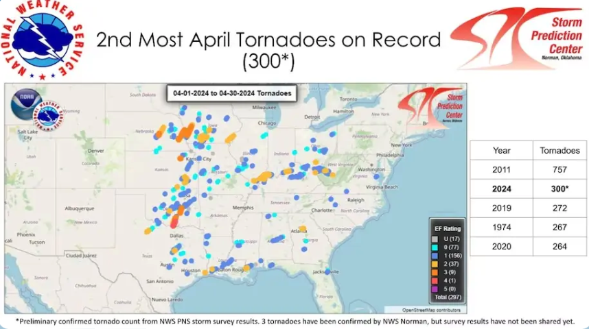
A programming note:
There will NOT be a Thursday Evening email this week. I will be attending an out of state funeral on Thursday and Friday. Like last week, I have updated the daily forecast through Sunday, this morning, 05/02, as usual. The next full site update will be either Friday (5/3) evening or Saturday morning (5/4). Then back to the regular schedule.
Welcome to the month of May!
From today through Sunday: When it isn?Äôt raining (and it won?Äôt be for much of the time until Sunday) there will be lots of clouds in the sky. There may be some thunderstorm activity today.
The latest Rapid Refresh analysis shows the center of high pressure over upstate New York at this hour. It is slightly deepening keeping convection going, so included thunder for another hour across northern New Hampshire.
Previous Discussion... Impacts:
*No significant weather impacts expected
Some convection is rolling over the ridge early this morning and is just about at the Vermont-New Hampshire border at the time of this writing.
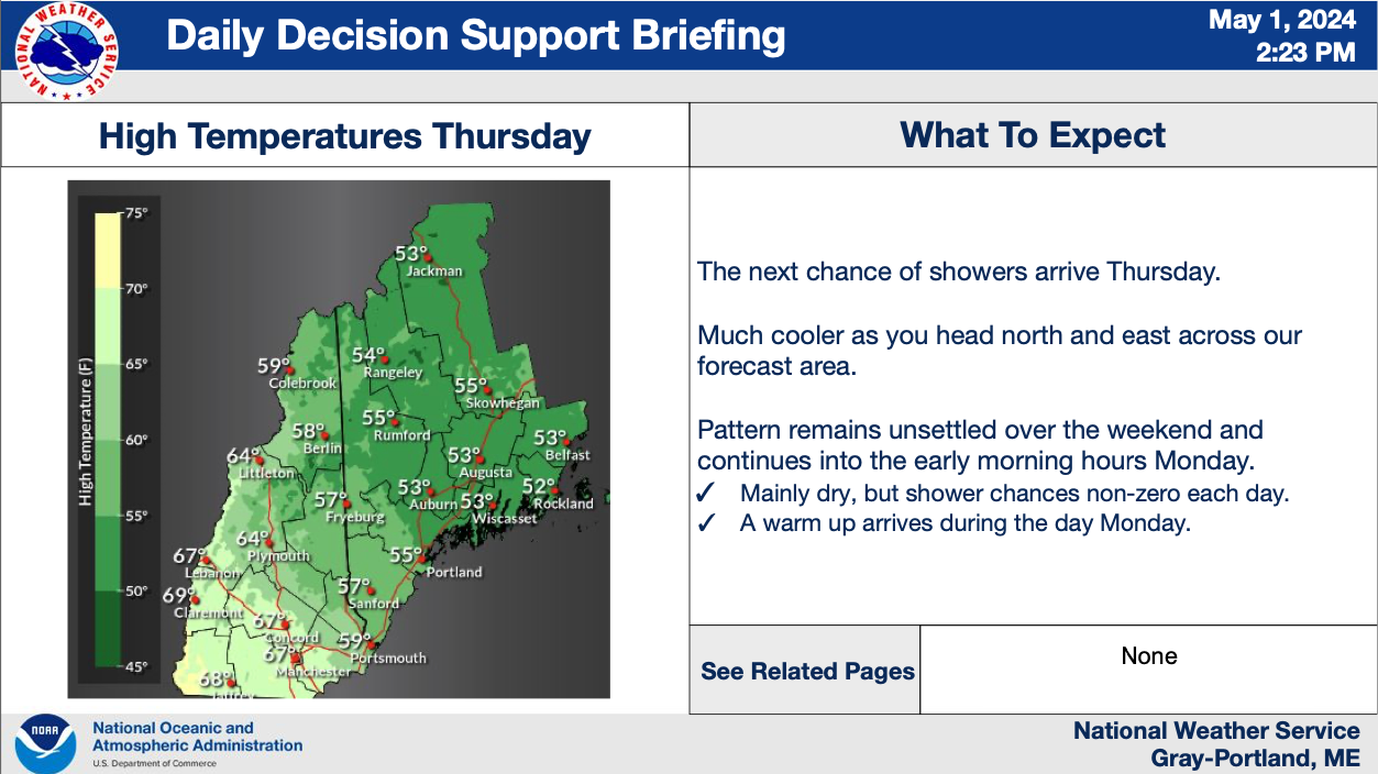
Otherwise a band of clouds associated with the warm front aloft persists across the area with more forming upstream. These will hamper warming today for Maine and Eastern New Hampshire with highs expected to cap out in the low to mid 50s. The exception will be in western and southern New Hampshire where, when the surface warm front arrives, skies likely clear enough to allow temperatures into the upper 60s and low 70s. How far into the state this penetrates will be a question, but it looks like it could make it to at least Concord before temperatures sharply drop off. Positive theta-E along the warm front will also provide some instability for thunderstorms to develop. Rain showers will cross central Maine as well, but with the much cooler temperatures these will not have a threat of lightning.
Tonight into Friday:
Impacts:
* No significant weather impacts expected
All showers will taper off quickly heading into the night as a ridge begins to build into the area. This subsidence following the rain will likely result in patchy fog in the usual valley locations. Skies will start to clear from north to south, but only partly, so would expect most of the area to see lows in the 40s with some upper 30s north of the mountains where the most clearing will be realized the most.
Skies will remain partly cloudy through the day Friday, but with surface high pressure and a 500mb ridge continuing to build in we will remain dry with highs in the upper 50s to mid 60s.
Long range:
Anomalously high heights will persist over the Northeast through the duration of the extended forecast period... which will allow an anomalously warm airmass to build into the mid levels. In spite of this, it is still very much Spring in New England, and surface flow relative to the Gulf of Maine will ultimately call the shots regarding the sensible weather conditions. High pressure initially sits offshore this weekend, which keeps conditions humid and cooler than average. A cold front crosses late in the weekend with rain showers, with offshore flow in its wake bringing fresh flow out of the west or northwest into New England with warmer, drier air and sunnier skies. The weather pattern remains active however with another chance for rain around the the middle or latter part of next week.
Starting Friday night... surface high pressure centered over Labrador builds south along the Eastern Seaboard, re-centering to near Nova Scotia by Sunday. At the same time, low pressure near Hudson Bay slowly drifts east... bringing a slow-moving cold front into the Northeast. Resultant northeasterly-turning- southeasterly flow over our forecast area brings a steadily moistening column over the weekend, leading to increasing clouds and eventually rain showers late Saturday through Sunday. Temperatures on Saturday will vary depending on proximity to the coastline, with 60s over the interior of New Hampshire but 50s more likely in Maine and toward the Seacoast... and the immediate coastline sticking closer to Sea surface temperatures in the 40s. Thickening cloud decks and continued onshore flow produces a fairly dreary Sunday with temperatures in the 40s and 50s and rain showers. Forcing doesn`t look great, with the parent circulation well north of the region; ensembles bring on average 0.25-0.4" of rain however would expect higher and lower amounts, with an inch or so on the high end given decent moisture depth and some areas possibly staying dry. Instability doesn`t appear to be a major factor at this time.
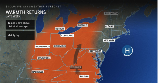
The cold front crosses late Sunday into Monday, with showers ending by the end of the day Monday... though cyclonic flow and slowed frontal movement may delay improvement. Drier flow out of the west will allow for stronger mixing with minimal maritime influence, in turn allowing temperatures to warm strongly into the 70s... except the 60s along the coast where a weak onshore component persists, and across the north where clouds and some showers likely hang around. Tuesday sees a similar fate with highs again in the 60s and 70s and a sunnier mix of clouds and sun.
The next wave moving through the upper level pattern approaches New England by the middle of the week with flow again turning southerly to onshore. Thus, can expect cloudier... more humid... and likely cooler and showery weather to make a return sometime in the middle or end of next week.
Join my email list and get the EVERY THURSDAY EVENING E-mail blast that details the upcoming weekend weather. Plan ahead for the upcoming weekend! This is the same list I use for Winter Storm Warnings, hurricane alerts, and other weather hazards. It is free and mostly ad free. Cancel at anytime. I do NOT harvest e-mail addresses, nor do I sell them.
Site News
Welcome to my website!
Send me an E-mail if something is not working!
05/01/2024 - I have updated the annual rainfall Snowfall section.
04/21/2024: The Climate Panel has transitioned to the Summits forecast for Mount Monadnock. I hope this is helpful.
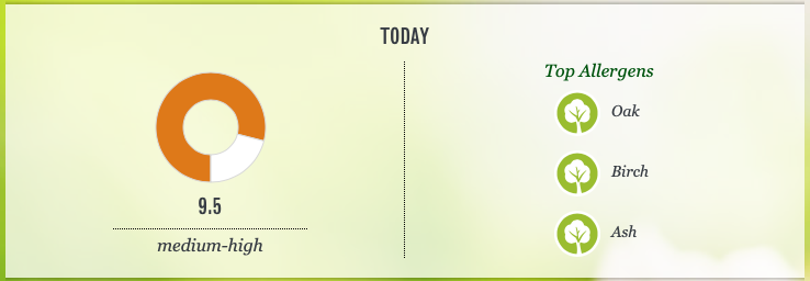
03/31/2024 -Weather Graphic #3 will transisition from the Flu report to the allergy report starting on 4/01/2024
12/31/2023 - The Almanac section has been updated with 2024 data.
Link to my weather instrument reading on Weather Underground - Weather Readings
Precipitation amounts have been updated for April- Link
I have updated ALL contact me e-mail addresses on the site. If you tried one, and I did not respond, please try again. I ALWAYS respond.
Contact e-mail: weathermail@richlefko.com
Those pixs and video will be posted here: Storm Pix/Video Page. Please let me know if I can use your name, and at the very least, include a location.
I feature a 'Picture of the Week' every Friday. Do you have a great picture you would like to share? I would be happy to post your best shots in that weekly feature. Contact me if you are interested.
Traveling? A location to avoid, in the world, is posted every day in the USA/World weather page. Take a look at today?Äôs place to avoid.
Regional Synopsis
SYNOPSIS...
Warm conditions in southwest New Hampshire will sharply contrast cool, low overcast conditions elsewhere today. Rain showers are possible anywhere, but will generally be most likely and most frequent over central...northern...and eastern areas. Drier weather returns Friday into Saturday, however the pattern remains unsettled and humid with increasing clouds and more showers late in the weekend. The upcoming work week starts on a drying, clearing, and warming trend.
SYNOPSIS...
A weak low pressure will bring scattered showers near the coast Thursday. High pressure north of our region will bring dry and seasonable weather Friday and most of Saturday with onshore winds. An approaching front should bring showers late Saturday into Sunday. Dry and warmer weather is expected early next week.
LONG TERM /FRIDAY NIGHT THROUGH WEDNESDAY/...
Key Points:
* Scattered showers late Saturday into Sunday
* Warmup early next week
Weather Headlines
Summer arrives on June. 20, 2024, at 4:51 PM EDT
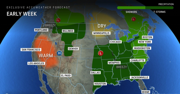
Unsettled weather follows us into the weekend

Regional Weather Discussions
Updated once in the morning-These are provided by the NWS, WMUR-TV, or me...
Manchester, NH: Last update: 5/02 - 7:55 AM
This unsettled weather pattern with more clouds, shower chances, and cooler air in place continues on. Temperatures will slowly try to climb into the 60s Thursday and Friday, but likely slide back again over the weekend with more clouds and cooler air off the ocean. Highs both weekend days will only be in the 50s. Showers return by Sunday afternoon and evening.
Mostly cloudy skies with scattered t-showers today. Huge range in highs today from the mid 50s in parts of the North Country to the lower 70s with any thinning of clouds in SW/southern NH this afternoon.
Any showers wind down tonight, partial clearing with some fog by morning. Lows in the 40s.
Mainly dry on Friday but still cloudy with a few PM sunny breaks. Highs in the 50s to the lower 60s. A few areas of drizzle are possible.
Saturday and now Sunday's temperatures will slip back into the 50s. Sunday will likely feature a few showers, especially in the afternoon and evening.
Brighter and warmer by Monday and Tuesday of next week.
Picture of the week - New every Friday
Kinderdijk, Netherlands

Your picture could be featured here-Ask me how?
Current Boston Radar Loop - All Radars

Climate Information (Peterborough, NH)
This section is updated every morning.
Last Update: 5/02 - 7:48 AM
The current average temperature spread for this time of year:
High: 61 Degrees
Low: 38 Degrees
Record High: 1894: 82 Degrees
Record Low: 1964: 25 Degrees
Lake Winnipesaukee Water Temperature: 47.2 degrees
The Summits Forecast
THE FORECAST FOR MOUNT MONADNOCK, NH
Summits of Mount Monadnock and North Pack Monadnock Mountain
645 AM EDT Thu May 2 2024
...Recreation forecast for summits of Mount Monadnock and North Pack Monadnock mountain...
REST OF TODAY...
Summits obscured. Isolated showers. Highs in the mid 60s. Southwest winds around 15 mph shifting to the west this afternoon. Chance of rain 20 percent.
TONIGHT...Summits obscured in the evening, then summits in and out of clouds. Scattered showers in the evening. Lows in the lower 40s. Northeast winds 10 to 15 mph with gusts up to 25 mph. Chance of rain 30 percent. FRIDAY...Summits in and out of clouds. Highs in the upper 50s. Light and variable winds.


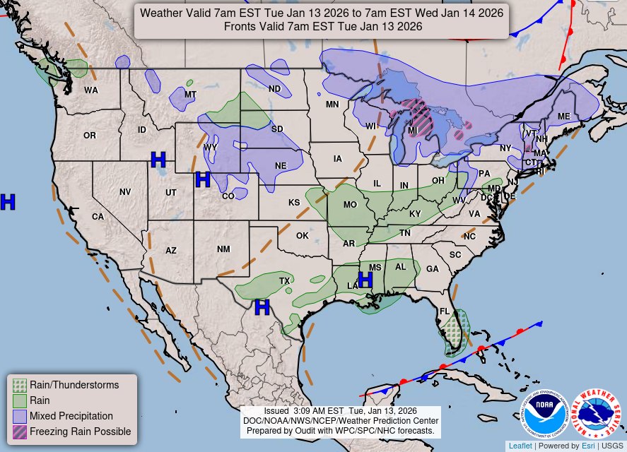
The latest National Weather Map direct from the NWS.
RichLefko.com Sponsors
Please patronize those running ads below - They are the lifeblood of RichLefko.com
Anrik Irrigation

My Longest Sponsor, I am pleased to present Anrik Irrigation. Anrik Irrigation is a full service lawn sprinkler company. They perform a variety of services, installation, maintenance, fall blow-out, spring start-ups, and offer a great brand of deicer for winter. Ask me!!
Freedom Cad Services

Freedom Cad offers PCB Design Services, Enginerring Services, and other value added services. They are headquartered in Nashua NH.
Freedom Cad Offers: PCB Design Services, Engineering Services, and Value Added Services.
Download their free eBook, The Printed Designer?Äôs Guide to Executing Complex PCBs. Download Now.
Joe Shimer.Com

I hold a Broker license in Massachusetts and New Hampshire. I have earned National Team Leadership Awards for the years of 2007, 2006, 2005, 2004, 2003, 2002, 2001, 2000, 1999, and 1998.
I adhere strictly to the Realtor Code of Ethics.
I offer Seller and Buyer Representation.
If you'd like to ask me about Joe, please feel free to send me an e-mail.
Peters of Nashua

Located minutes outside of Manchester, Peters Nissan of Nashua is the go-to Nissan dealer serving Nashua and the greater Manchester area including Salem, Peterborough, Concord, and Lowell. We are here to meet your every automotive need whether you are in the market for a new or a used model, require a car loan and financial assistance, or want routine service or extensive repairs. Our commitment is to customer, no matter what.
Peters of Nashua has been serving the areas automotive needs since 1955. Family owned and operated. They service ALL makes and models and I highly recommend them. Ask me
Patten Energy

Discover the Patten Energy Difference
At Patten Energy, our philosophy is simple. We believe that bigger is not always better! We are neighbors serving neighbors - where you?Äôll always be referred to by name, never as just another account number. We are dedicated to maintaining the personal touch and quality care only a family run business can provide.
I use Patten Energy, and I heartily endorse them.
Dan's Tutorials

If you own ANY Apple products, I can highly recommend Dan's Tutorials. I am a visual learner and Dan's vidoes walk you through each and every option whether you are using an iPad/iOS, or a Mac/Mac OS, or an Apple Watch. Dan has you covered on ALL Apple devices.
Scott Doremus - Woodworking and Home Improvement

Specializing in:
Decks, Sheds, Pergolas, Stairs, Doors, Windows, Barn Doors, Exterior Repairs, Plumbing, Light Electrical
Serving North Middlesex County MA and the Monadnock Region of New Hampshire
Call for a free estimate: 978-735-9223
Email Scott by clicking here
I have used Scott for repair work at my house. I can highly reccomend Scotts work, his prices are reasonable, and he actually calls you back! Please contact Scott for a free quote and tell him you saw his ad at RichLefko.com!
Help those who put their lives on the line for us

The Wounded Warrior Project
Every warrior has a next mission. We know that the transition to civilian life is a journey. And for every warrior, family member, and caregiver, that journey looks different. We are here for their first step, and each step that follows. Because we believe that every warrior should have a positive future to look forward to. There is always another goal to achieve, another mission to discover. We are their partner in that mission. Veterans and service members who incurred a physical or mental injury, illness, or wound while serving in the military on or after September 11, 2001. You are our focus. You are our mission.
Thank you!
Subscribe to my Weather Alerts and get the Every Thursday Evening 'Weeked Outlook' E-mail. You manage your subscription.
Cancel whenever you want.
BTW, we do not sell, trade, give away, post, whisper, dream about, tattoo, print or share your e-mail addresses with anyone...EVER!
When you subscribe, your address goes directly to me, not some online service.
Subscribe once and get all e-mails and warnings!
Yes, you can subscribe to multiple addresses, home, office etc.
Zero cost - No ads-No tracking
Questions/Issues/Problems/Say Hi: Contact me: E-mail
Add a RichLefko.com icon to your iPhone or iPad. It is easy. If you find yourself frequently visiting a website or using a web app on your iPhone or iPad, it is very easy to add a shortcut icon directly on your Home screen using Safari that you can quickly tap to launch the site. This is how:
How to Add a Website tile to Your iPhone or iPad Home ScreenProud member of the National Weather Service Skywarn Program
